Nick's Ski Resort Guidebook WHISTLER BLACKCOMB

Maps
Given the size of the Whistler Blackcomb resort area (8,171 acres), the number of runs (over 200) and the variety of terrain, maps are a very helpful tool to understand, plan and guide your skiing or snowboarding during the day.
These are some of the maps that I use to help plan my day at the resort:
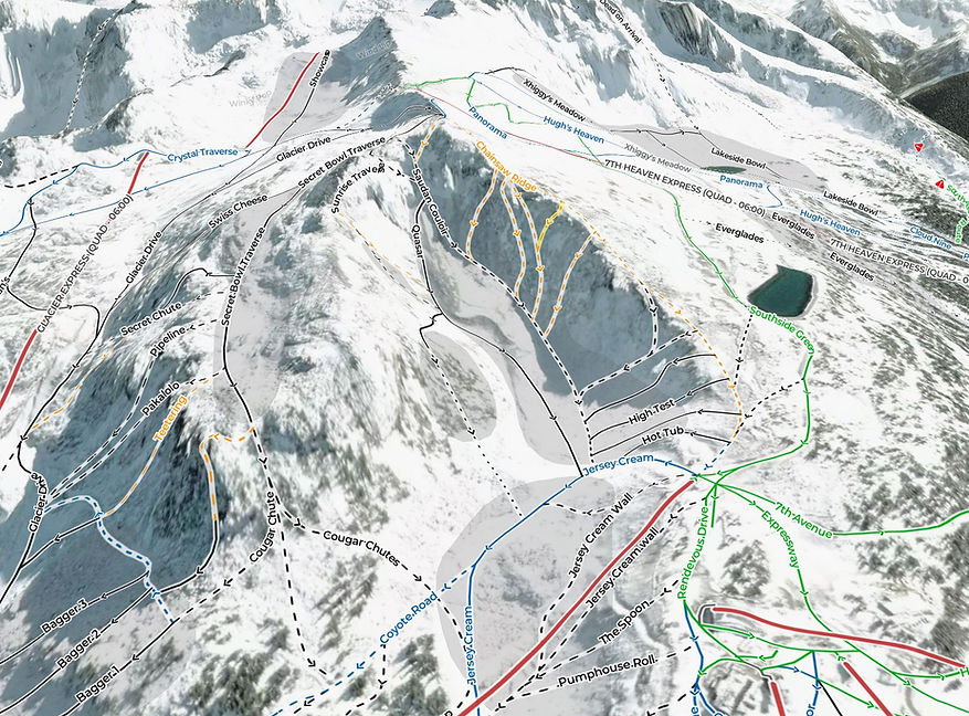
Whistler Blackcomb Official Winter Trail Map
This is the official map for Whistler Blackcomb and presents a 3D quasi realistic view of the resort area.

Source: Whistlerblackcomb.com
Openskimap.org
Openskimap is a free website based map for ski resort around the world. It draws data that has been entered into OpenStreetMap by volunteers and enthusiasts. I have spent a considerable amount of time over the last couple of years working to improve the quality and coverage of the map data for Whistler Blackcomb. What you see today on OpenSkiMap is a very good representation of the areas and runs in the resort area.
Openskimap lets you look at the resort from a flatmap, 2D perspective as well as a 3D, satellite image view. You can also zoom in and rotate the map to get a great view of the areas you want to ski on a given day. Openskimap is also mobile friendly and works well on smartphones and tablets.
Source: Openskimap.org
Epic App
The Epic mobile app is the official app of Vail resorts and offers the status of runs and lifts at Whistler Blackcomb. It also offers a interactive map that shows runs and lift wait times. This is useful as it can help you decided if you want to head over to an area (or not).

Source: Epicpass.com
ULLR Maps
The Whistler Blackcomb map by ULLR is a highly detailed topographic map of the resort area. It was developed by Alex Hordal who lives and works in Whistler as a Ski Patroller. If you are planning to ski some of the more extreme parts of the resort or to do backcountry skiing this is a great map to consider.

Source: Ullrmaps.com
ShadeMap
ShadeMap is a cool online map solution that lets you see what parts of the mountains will be in sun or in shade on a given day and time. This is a great tool if you want to figure out the best area to ski for morning or afternoon sun or to see what parts of the resort have been protected from the sun (and hence may still have some dry snow).

Source: Shademap.app
Return to Home page